 |
| Louise's photo captures the frosty morning sun on the conifers with a glimpse of the cottage. |
Tuesday, 30 December 2014
Winter sun
Green Tourism
The cottage has been recently accredited with the gold rating. Thank you to Forest of Bowland AONB for help and advice, Treshnish farm, Mull for inspiration and Green Tourism for the award.


Wednesday, 3 December 2014
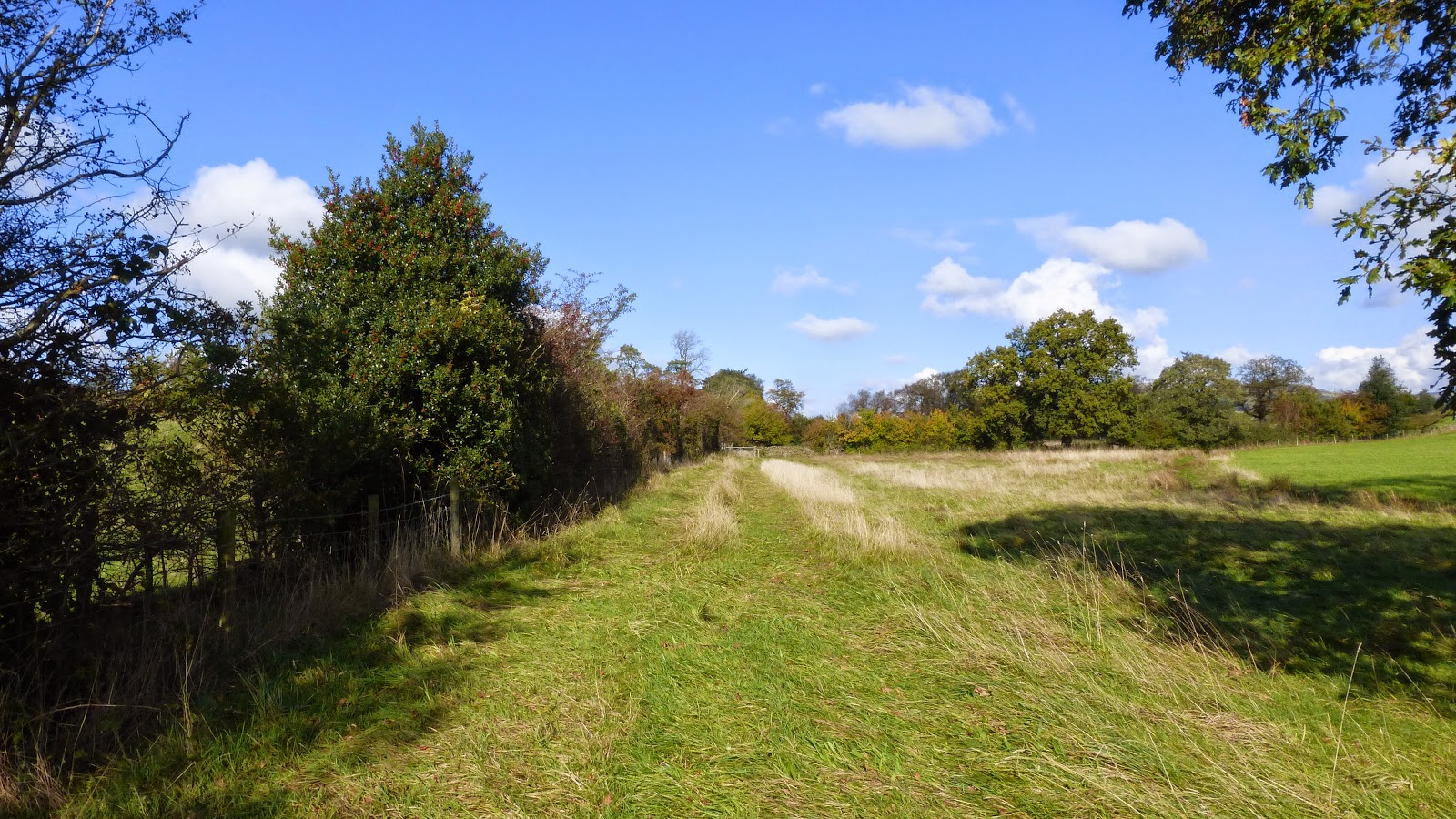
Walk the Roeburndale West to the Salter Road
On a good day the walk up the Roeburndale West road offers some lovely views to the Three Peaks and the fells to the north.
If you walk to High Salter (Salter is the name for a deer entrance to a park in medieval times ) you can get onto the old road to Slaidburn, a charming village with a pub, Hark to Bounty, to refresh the weary walkers. The walk from High Salter SD608625 to Slaidburn takes 4 hours one way. You will be very lucky if you see the now rare Hen Harrier as the latest fledgings were killed by unknown persons as the tags disappeared. Parts of this road called the Old Hornby road are marked as Roman and if you decide to do this walk you can veer off to the left where the Roman road goes north towards Lowgill instead of going on to Slaidburn.

 |
| the Roeburndale West road towards Barking Bridge |
 |
| the steep hill down to the bridge with Mallowdale fells in the background |
 |
| the gate that leaves the tarmac at High Salter farm goes on to the old track |
 |
| the track leading to Slaidburn |
 |
| views on a clear day to the Lake District mountains |
 |
| the Three Peaks from the track |
 |
| onwards to Slaidburn |
 |
 |
| you could go towards Winder, Littledale and the top of Roeburndale |
 |
| towards the north |
 |
| on the way back you can choose to go back on the public footpath through the woods and fields |
 |
| tree canopy showing the density of trees of Roeburndale |
 |
| Roeburndale woods |
 |
| gnarled trees and old stone walls are common in these parts |
 |
| you can go down the footpath through Backsbottom |
 |
| and continue down towards the Roeburn and footbridge. |
Saturday, 29 November 2014
Walk around Cowdber , Overtown and Burrow
On this short walk we found glimpses of the course of the Roman road which in part can be walked along (Professor Alan R. Wellburn's booklet "Leck, Cowan Bridge and the Brontes")
 | |
| After leaving Woodman's Lane SD 620751 go towards Cowdber Farm --ber is Old English for hill -and continue on the public footpath . |
 |
| After Cowdber ,although the public footpath goes straight on where it crosses the course of the Roman road, you can turn left onto the Roman road course and follow it all the way to Overtown . The raised ground "agger"in the photo may be the remains |
 |
| Although not marked as public the footpath looks well used and |
 |
| you will pass a small holding with goats, ducks and chickens |
 |
| the view here is a glimpse to the northeast of Ingleborough from the track |
 |
| still visible here, the old track leads eventually to Overtown where there is a parish boundary stone on the inside verge just by the corner of the road between Garghylle Dyke farm and Overtown which is an original Roman milestone, much reduced in height and hidden beneath much ivy on the right after leaving the track and getting onto the tarmac, |
 |
| depression in field possibly part of the course |
 |
| Before the ford/bridge at Overtown SD629763 there is a stile into a manicured garden but it is still a public footpath and this goes to Cowan Bridge |
 |
| Cross the bridge over the Leck and then turn left onto the public footpath through fields towards Burrow Hall |
 |
| looking back towards the fells |
 |
| you might see a donkey |
 |
| Towards Burrow Hall there are many stone wall remnants and archaeological remains like this above . Burrow Hall has the remains of a Roman fort (Calacvm) in it's grounds ,unfortunately not accessible, but you can glimpse the small ravine above Leck Beck to the left of the track where the east wall was. |
 |
| Iron implement wheels on the wall of Burrow Hall farm which you will pass before turning left onto the tarmac of the A683 |
 |
| Burrow bridge over the Leck |
 |
| Back onto turf after turning left onto the footpath along the Leck towards Woodman's Lane--the Roman remains would be to the left of the photo. |
Walk around Tunstall, the Brontes and a short walk to the Roman road
The grade 1 listed church of St. John the Baptist is down Church Lane at Tunstall (SD 6147390) via the A683 to Kirkby Lonsdale. It is well known for being attended in 1824 by the Bronte sisters when they were at the Clergymen's Daughters' School at Cowan Bridge. Charlotte's novel "Jane Eyre" has the school as Lowood and the church as Brocklebridge -the journey to the latter "where a bitter wind , blowing over snowy summits to the north, almost flayed the skin from our faces" made for an unhappy time. Luckily for us, when we visited it was the warmest of autumn days
 |
| The church with sign pointing in the direction of Woodman Lane north |
 |
| A Roman votive stone in the North aisle |
 |
| the oldest parts date back to the C13th |
 |
| the footpath stile in the grounds |
 |
| Sundial above main entrance |
 |
| Sundial base C18th in grounds |
 |
| Further on down the road go across a field on your right and you eventually get onto the public footpath which becomes a charming old track after the bridge over the Cant Beck |
 |
| Keep on going |
 |
| and you will see Longriggs Barn over the fields |
 |
| Straight ahead northwards is part of the course of the Roman road from Wennington towards Barbon- the Ribchester-Carlisle road (see Dr. Keith Horsfield's research "An Old Road from Lancaster to Ingleton:possibly a Roman route?"for more on Roman tracks in the area ) |
Maiden Bridge Gallery
This internationally renowned gallery is only 10/15 minutes from Wray by car and could be part of a day's walking around the area.The name "Maiden"is of Celtic origin, dun being a hill fort possibly part of the Celtic Kingdom of Rheged. David and Hannah welcome visitors by prior appointment.


Subscribe to:
Posts (Atom)